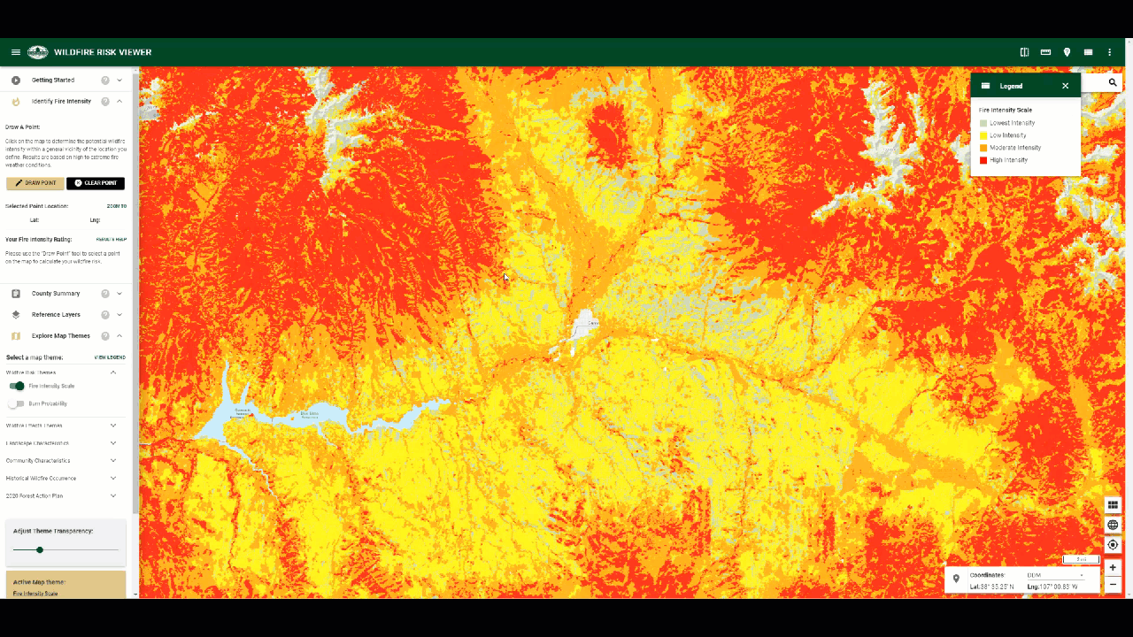
Identify Fire Intensity
The Identify Fire Intensity tool summarizes the potential fire intensity under high to extreme weather conditions for any specific location of interest. It is intended to inform homeowners and business owners of the impending risk for their location based on surrounding conditions.
It allows you to draw a point on the map and automatically retrieve this information for a quarter-mile buffer. A quarter-mile buffer is used because risk from wildfire is dependent on the conditions surrounding a location, not the conditions at specific site. The information is summarized and presented to you for review. A link is also provided to connect you to the Colorado State Forest Service mitigation web site where more information can be obtained.
To use the Identify Fire Intensity tool, follow the steps outlined below:
Click the Identify Fire Intensity toolbox to expand
Click the Draw Point button
Click on the map to draw a point
The Identify Fire Intensity will return the fire intensity rating for that location
Press Zoom To, to zoom the map into the point location
Press Results Help to see more information about the Fire Intensity results.
Click Learn How to Reduce You Risk to learn about wildfire mitigation.
Press Finish Drawing to deactivate the Draw Point tool. The Intensity Rating result will remain.
Click Clear Point to dismiss the point on the map and the results
Understanding the Results
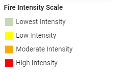
The tool uses the Fire Intensity Scale (FIS) layer to determine the potential fire intensity for the specified location. FIS quantifies potential fire intensity based on high to extreme weather conditions, fuels, and topography. It is similar to the Richter scale for earthquakes, providing a standard scale to measure potential wildfire intensity by magnitude.
As an alternative way to deal with Byram’s wide-ranging fireline intensity values, Joe Scott (Pyrologix LLC) suggested using the common logarithm of fireline intensity (kW/m) as a standard scale of wildfire intensity (called the Fire Intensity Scale, or FIS).1 The common logarithm is also used in the Richter scale of earthquake magnitude; each unit increase on the Richter scale represents a ten-fold increase in the amplitude of ground shaking. The same is true of the FIS. Each unit increase in FIS is a meaningful ten-fold increase in fireline intensity. FIS values range from just less than 1 (10 kW/m) to just over 5 (100,000 kW/m), suggesting a classification by orders of magnitude that lends itself to a multi-class dataset.
FIS in Colorado consists of 4 classes where the order of magnitude between classes is ten-fold. The minimum class, Class 1, represents the lowest wildfire intensities and the maximum class, Class 4, represents highest wildfire intensities. It is important to remember that each class is ten times the intensity of the previous class.
To ensure that FIS provides a rating that not only considers the specific location defined by the user, but also incorporates risk for the surrounding area, further modeling was undertaken that utilizes a decay function to calculate risk for any given location. A 0.25 mile buffer was used, with values closer to the user defined location weighted higher than those farther away. This results in a value that considers the risk around any location, not just the value at the specific location. This value is returned in the results of the Identify Fire Intensity tool.
The FIS data is modeled at 20-meter resolution. Accordingly, while this is accurate enough to provide general ratings, it is not appropriate for site specific recommendations, i.e. not appropriate for defensible space or home assessments. For site specific advice, please contact a local mitigation planner for help as they can incorporate local conditions not available in the risk assessment scale of data.
References
Scott, Joe. November 2006. Off the Richter: Magnitude and Intensity Scales for Wildland Fire. A non-published white paper prepared for the AFE Fire Congress, November 2006, San Diego, CA